Looking for design inspiration? Browse our curated collections!
May 6th, 2013 - 03:54 AM

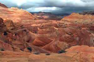
The hike to North Coyote Buttes (The Wave) is one to be desired. Three grueling miles of hills, sand and slick rock - with a map in hand that shows pictures of landmarks to follow and pinpoint in the distance. The B.L.M. office in Kanab, UT provided us with the map one day prior to when we drew out permits for the hike.
My buddy, Trent Hagen and I set out on our quest at first light to be certain we are on course to reach the Wave without complications. We have high hopes of photographing this uniquely shaped landscape filled with layers of sandstone. Before leaving the truck, we carefully stock our packs with camera gear, food and plenty of water. I prefer to take extra water over lenses as I know six miles of hiking in the desert is going to be a challenge.
Canon 17-40mm is my lens of choice. All others are left behind to make room for water. Skies are cloudy and rain forecast, so that simplifies my choice because I don’t want to risk swapping lenses in a rainstorm. My plan is to capture the landscape the best I can with a wide angle lens.
Shortly after leaving the truck we follow a stretch along Coyote Wash for about ˝ mile until we came to an old road that leads to Coyote Buttes. Point 1
The old gravel road soon turns into thick, deep sand, when low and behold it begins to rain. This only intensifies my fears of hiking into the desert, but the thought of having a wet, shiny surface to photograph disregards all apprehensions.
We gradually move forward en route of a sandstone ridge, where distinct peaks stand out on the horizon. Point 2
We stop on occasion and take pictures of our surroundings to ensure we’re able to find our way back. The landscape is vast, deep and wide. After crossing the sandstone ridge we reach Point 3 on the map, turn right (south) and climb up slick rock, which moves parallel to the ridge toward Point 4.
We continue walking south on the slick rock when Twin Buttes comes into view. Point 4
At this point we climb to the right and go around Twin Buttes. It may look easier to go left, but don’t be misled by false intentions. We soon reach Point 5 on the map.
From this point we move across slick rock and focus our eyes into the far distance at a large crack in the wall and use it as a landmark. It seems like we’ve been walking forever. Dredging forward in the rain, we straddle a pair of sand dunes and eventually come upon Point 6.
At this point we descend through a large wash and begin climbing a steep sandy hill. This is no easy task and I stop for frequent breaks. Once we get through the thick sand, we are at the opening to the Wave. Game on!
Comments
There are no comments on this blog. Click here to post the first comment.